I was surprised by some of the comments in the McNeese Ducks Unlimited thread. NOT the comments by anti-DU people; the exaggeration, misinformation, and outright lies I've encountered regarding Ducks Unlimited activities in my professional career exceeds those of all other topics combined. But by the comments regarding aerial survey and harvest estimates in Louisiana.
I'll do it in 2 posts so it won't be such a monster.
Aerial Surveys:
Aerial survey data in coastal Louisiana come from a series of transects flown in the same manner since 1969. Here is what those transects look like:
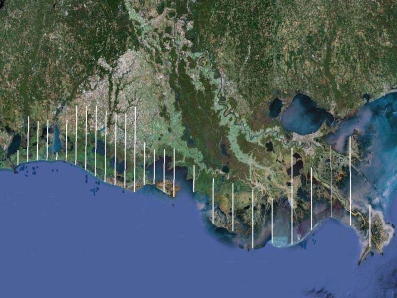
The northernmost point of the transects is I-10, and that is only in the western portion of the state, so you can see how much of the state is NOT covered by the aerial survey. That survey takes 3 days to fly, the swath we count is 220 yards out both sides of the plane, the total area surveyed represents a 3% random sample of all habitats in coastal Louisiana, and estimates are generated from that sample.
We also do a "cruise" survey of Catahoula Lake in conjunction with the coastal transects. A cruise survey attempts to count every duck on a prescribed area. We report the number of ducks on Catahoula Lake with the coastal transect estimates in our reports found at:
http://www.wlf.louisiana.gov/hunting...erfowl-surveys
We also do "cruise" surveys of selected habitats in both NE and NW Louisiana. Again, those selected areas are only a portion of the total habitat in those parts of the state, but they are NOT a random selection of all habitats where all areas might possibly be selected. Consequently, we can't generate valid estimates from those data, which is why those counts are reported in the COMMENTS section of the reports. But although those surveys can't generate estimates of total population size the way the coastal transects can, if we fly the same areas every survey, we CAN make credible month-to-month and year-to-year comparisons.
So major points to consider:
1) Actual estimates or counts by themselves are NOT meaningful. We are not surveying anywhere near all the areas of the state, AND we aren't seeing all ducks even in the locations we are surveying.
2) The value of the coastal survey comes from the random location and consistent flying of the transect lines over many years. That gives us reliable year-to-year differences in duck numbers in the face of changing habitat conditions.
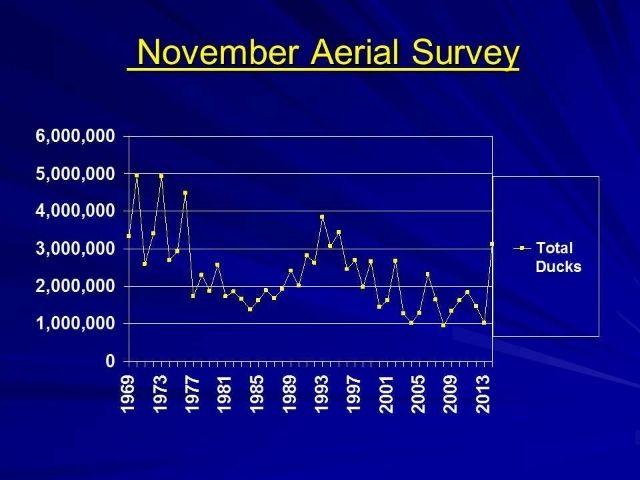
The only recent summary I have is something I did recently for the Commission in considering of setting season dates. Here is a summary of the November Aerial Survey data for coastal Louisiana and Catahoula Lake.