
|
|
|
|
|||||||
| General Discussion (Everything Else) Discuss anything that doesn't belong in any other forums here. |
 |
|
|
Thread Tools | Display Modes |
|
#1
 10-31-2015, 02:13 PM
|
|||
|
|||
|
I'll do it in 2 posts so it won't be such a monster. Aerial Surveys: Aerial survey data in coastal Louisiana come from a series of transects flown in the same manner since 1969. Here is what those transects look like: The northernmost point of the transects is I-10, and that is only in the western portion of the state, so you can see how much of the state is NOT covered by the aerial survey. That survey takes 3 days to fly, the swath we count is 220 yards out both sides of the plane, the total area surveyed represents a 3% random sample of all habitats in coastal Louisiana, and estimates are generated from that sample. We also do a "cruise" survey of Catahoula Lake in conjunction with the coastal transects. A cruise survey attempts to count every duck on a prescribed area. We report the number of ducks on Catahoula Lake with the coastal transect estimates in our reports found at: http://www.wlf.louisiana.gov/hunting...erfowl-surveys We also do "cruise" surveys of selected habitats in both NE and NW Louisiana. Again, those selected areas are only a portion of the total habitat in those parts of the state, but they are NOT a random selection of all habitats where all areas might possibly be selected. Consequently, we can't generate valid estimates from those data, which is why those counts are reported in the COMMENTS section of the reports. But although those surveys can't generate estimates of total population size the way the coastal transects can, if we fly the same areas every survey, we CAN make credible month-to-month and year-to-year comparisons. So major points to consider: 1) Actual estimates or counts by themselves are NOT meaningful. We are not surveying anywhere near all the areas of the state, AND we aren't seeing all ducks even in the locations we are surveying. 2) The value of the coastal survey comes from the random location and consistent flying of the transect lines over many years. That gives us reliable year-to-year differences in duck numbers in the face of changing habitat conditions. The only recent summary I have is something I did recently for the Commission in considering of setting season dates. Here is a summary of the November Aerial Survey data for coastal Louisiana and Catahoula Lake. 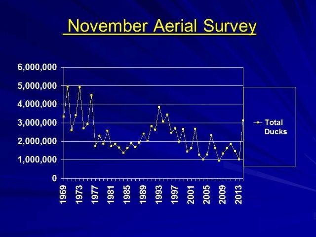
Last edited by Lreynolds; 10-31-2015 at 02:35 PM. 
|
|
#2
10-31-2015, 02:13 PM
|
|||
|
|||
|
Harvest Data:
Harvest data are collected from a random sample of hunters each year. They are NOT from the questions you are supposed to be asked when you purchase your license. Those questions are used to divide hunters into 3 categories: 1) Low Kill - did not hunt or reports killing 0 to 10 ducks 2) Medium Kill - reported killing 11-30 ducks 3) High Kill - reported killing >30 ducks Every 2 weeks, LDWF sends a list of names, addresses, and Kill category for every duck hunter that buys a license during that 2 week period to the USFWS. Then they select a sample: 2% of Low, 3% of Medium, and 5% of High kill hunters, and ask them to participate in the harvest survey by sending them this form and asking them to fill it out and return it at the end of the season: 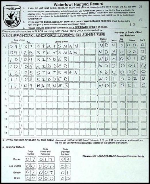 From those "diaries" submitted by selected hunters, they estimate the number of active duck hunters, days hunted and ducks killed. That is called the "Questionnaire Survey" and is the first part of the federal harvest survey. From the hunters that participated in the Questionnaire Survey last year and reported killing at least 1 duck, the USFWS selects a sample and asks them to participate in the "Parts Survey" the following year. This is the survey where selected hunters send in a wing from every duck they kill and the tail from every goose they kill using pre-paid/pre-printed envelopes provided by the USFWS throughout the season. Biologists get together in late February at each Flyway's "Wing Bee" and determine the species, age, and sex of every wing/tail sent in. The Parts Survey is particularly important because not only does it allow us to estimate species-specific harvest, but it provides the Age-Ratio of the harvest, which after correcting for differential vulnerability of juveniles and adults (which is done using band/recovery data), is the best estimate we have for large-scale reproductive success. Those data are used in every population model used in our harvest management strategies, which are the basis for our hunting regulations. Taken together, the Questionnaire Survey and the Parts Survey provides the species-specific harvest estimates provided in the reports found at: http://www.fws.gov/birds/surveys-and...nd-harvest.php Here are the recent hunter number and duck harvest estimates for Louisiana, at least through 2012-13 seasons: 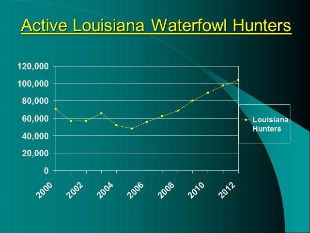 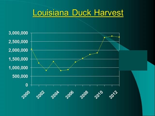
|
|
#3
10-31-2015, 02:29 PM
|
|||
|
|||
|
It is important to recognize that Aerial Survey and Harvest data are NOT directly comparable. It is quite possible that the harvest data may show we kill more ducks than the aerial survey data show we even have. Some of you made these points in the other thread, but I'll make them here again.
1) Aerial survey data are collected only in select portions of the state, but harvest data are collected from a sample of ALL waterfowl hunters statewide. So we know that aerial survey UNDER-estimate the actual population size. We also know that because more dedicated hunters are more likely to participate in the harvest surveys than casual hunters, the harvest estimates are likely OVER-estimates. Recent comparisons of the harvest data with banding data suggest the harvest data are overestimated by about 25%, but that is consistent across states and flyways. 2) Aerial survey data are collected during only a short period of time, but harvest data are collected throughout the entire seasons. Ducks migrate into, out of, and through our state constantly, but the aerial survey is conducted over only 9 total days during November, December, and January. So even in the areas we do survey, our counts are certain to be an UNDER estimate of how many birds were actually using that habitat during the course of the month. But harvest data accounts for hunting activity during the entire time. 3) The value of both aerial and harvest surveys is NOT the actual estimates, but the comparative nature of those data. By conducting the aerial surveys consistently over time, we get reliable comparisons month-to-month and year-to-year. I don't ever KNOW how many ducks are in the state, but I am pretty confident in whether there are more, less, or about the same as before. It's the same with harvest data. We can't know exactly how many ducks are actually killed, but by conducting the harvest surveys the same way in every state every year, we can be very confident if it is more, less or about the same year-to-year and between states.
|
|
#6
11-01-2015, 07:59 AM
|
|||
|
|||
|
Random Sampling of hunter data, when performed objectively, is the most accepted form of determining trends.
Aerial Surveys: -Audubon samples bird trends in a similar way, by placing capture nets in the same place(comparable to flight paths), for a specified time period(like 6:00 AM-12:00 AM) and maintain the exact routine for years. Last edited by Jrchip1; 11-01-2015 at 08:23 AM.
|
|
| Bookmarks |
| Thread Tools | |
| Display Modes | |
|
|


 Linear Mode

