
|
|
|
|
|||||||
| General Discussion (Everything Else) Discuss anything that doesn't belong in any other forums here. |
 |
|
|
Thread Tools | Display Modes |
|
#1
 06-01-2015, 02:53 PM
|
|||
|
|||
 I told my son, well maybe we shouldn't be in here, but it was as though we had just come through the wild life refuge. There was no sign like this on the entry where we came in the small channel, from the ship channel. So back in we went, back tracking the way we came, figured if we got stopped I could show my GPS tracks, as to how we got in, didn't want to keep forging ahead, for I didn't really know where it came out, and we entered from the ship channel, and I knew my way back. There was no other sign, I doubled check as we maneuvered back through. Im guessing this mean NO FISHING as well? wonder how much trouble one would get in. Here is where we were at 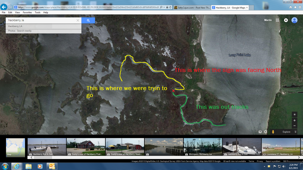 I found this map out lining the sabine wild life refuge, but I always see people fishing in the back channel of joes cove, as well lots of peps fishing along 27..... make ya wonder whats the deal-e-o ? 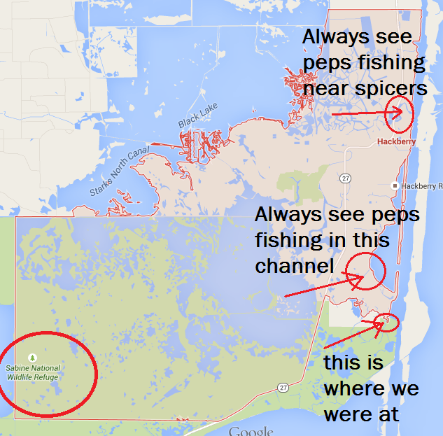

|
|
#2
06-01-2015, 03:05 PM
|
||||
|
||||
|
it is a wildlife refuge, there for it is our area, I would imagine it would be same rules as fishing rockafella refuge, you should be able to find some info online
|
|
#3
06-01-2015, 03:06 PM
|
||||
|
||||
|
|
|
#4
06-01-2015, 03:26 PM
|
|||
|
|||
|
That "Map" is not outlining Sabine NWR, its outlining the corporate limits of Hackberry. Interesting that it includes a good portion of Sabine. The map in the hunting and fishing regulations shows the boundaries of Sabine NWR:
http://www.fws.gov/swlarefugecomplex...ochure2014.pdf It is difficult to tell, but it is likely that you were partially within the NWR during your initial trip in, and once you turned around. However, you were not doing anything illegal. There are only certain areas that boat access is not allowed: http://www.fws.gov/southeast/pubs/SWLAcomplex_Fish.pdf
|
|
#5
06-01-2015, 03:43 PM
|
||||
|
||||
|
Marty,
Go to Google Earth and look in the layers section under "More" expand that and select "Parks/Recreation Areas". This will show you the boundary lines for the refuge. Sounds like you missed the sign on the way in or it is not there and saw one when you reentered the refuge boundary. Good luck!
|
|
#6
06-01-2015, 04:21 PM
|
|||
|
|||
|
Quote:
http://www.fws.gov/refuges/profiles/recEdMore.cfm?ID=43640[/QUOTE] thanks Smalls Thanks FF looks like I was in the clear............  [SIZE=2]Over 150 miles of refuge canals, bayous and waterways are open for recreational boating, fishing and crabbing from March 15-October 15. Boat launches are available at Hog Island Gulley and West Cove Recreation Areas along Highway 27. Both fresh and saltwater fish species may be caught on the refuge. Quality of fishing and species available vary seasonally. Recreation Areas along Highway 27 are open for fishing and crabbing year round. Castnetting for shrimp is seasonally available. Permits and special regulations apply; please contact refuge visitor center for specific information. [/SIZE] Ill be going back then, looked good!!
|
|
#7
06-01-2015, 04:21 PM
|
|||
|
|||
|
Quote:
|
|
#8
06-02-2015, 02:24 AM
|
|||
|
|||
|
Unauthorized entry would be if you entered when the refuge is closed, Oct 15 - March 15 each year, or when our dumb *** congress has a government shutdown.
|
|
#9
06-02-2015, 06:53 AM
|
|||
|
|||
|
I had a friend that entered the refuge from West Cove. He found some nice flounder. One ofthe federal. wardens told him he couldn't fish there. The next time he looked it had a sign up. He had found the warden's private flounder hole.
|
|
#10
06-02-2015, 07:08 AM
|
||||
|
||||
|
Quote:
post the location on here
|
|
| Bookmarks |
|
|


 Linear Mode

